

A complete site view can reveal progress that ground-level photos miss. Construction drone photography gives project teams an aerial record of site conditions, completed work, and areas that need attention. Regular images and video help teams compare progress across project stages, spot incomplete or out-of-sequence work, and communicate status clearly.
That visual record is most useful when it fits the project’s reporting needs. This article explains how drones support construction-site monitoring, what aerial imagery can show, and how mapping, 3D models, and camera specifications affect the information captured. It also outlines what to consider when choosing a professional service, so the resulting documentation supports clear project oversight rather than adding more files to manage.
Key Takeaways
- Construction drone operations in the United States must comply with FAA Part 107, including pilot certification, airspace restrictions, and operational guidelines, according to the Federal Aviation Administration.
- Learn how aerial images can support orthomosaic maps and 3D models for viewing site layout, elevation, and surface conditions.
- Understand how project needs shape drone and camera selection, including the imagery or data required.
- See how planned aerial photography, progress videos, and timelapse can create a consistent visual record across project stages.
Drones in Construction: How Are Drones Used on a Construction Site?
Drones capture aerial photos and video to help teams assess site progress, document conditions, and communicate changes. Their value depends on consistent viewpoints, clear reporting goals, and safe flight planning.
Construction Progress Photography and Video
Construction drone photography records work from above, including building footprints, access roads, staging areas, and visible changes between visits. Ground photography shows close-up details, while aerial images add site-wide context. Satellite imagery offers a broader view, but less control over timing and perspective. For example, repeated aerial views from the same angle can show whether a new structure has advanced since the previous update.
Video can connect these views into a clear sequence for project teams. Operators plan routes around cranes, active work zones, and people, and account for wind and precipitation when scheduling flights. They also avoid unnecessary views into neighboring properties. These steps help manage safety, privacy, and weather risks, but aerial footage is not a substitute for close inspection.
Progress Monitoring, Tracking, and Benefits
A consistent capture plan helps teams monitor construction progress across a site. A project manager can compare visible work with the planned sequence, identify incomplete areas, and flag work that appears out of sequence. For example, an aerial view may show one unfinished section while adjacent areas have advanced. The image supports review, while project records and direct site oversight provide essential context.
Repeatable viewpoints make comparisons between updates easier. Construction companies can use dated photos and video to discuss site status with project teams and clients, including areas that are difficult to reach on foot. A shared visual reference helps viewers orient themselves to site-wide changes and focus discussions on specific locations rather than relying only on written descriptions.
Project Documentation and Client Updates
Organized imagery turns each capture into useful project progress documentation. Group views by date, location, or work area, and add concise notes about visible changes. This makes it easier for clients and stakeholders to follow progress across reports. Drone images document what was visible during a flight; they do not establish the cause of a delay or replace technical inspection.
In the United States, construction drones must comply with FAA Part 107 regulations, including pilot certification, airspace restrictions, and operational guidelines, according to the Federal Aviation Administration. Commercial pilots therefore need the required Part 107 certification. Insurance is a separate project-planning consideration; teams should address coverage in their agreements rather than assume that certification settles it. Clear reporting and defined capture areas support accountable updates.
Aerial imagery, orthomosaic maps, and 3D models
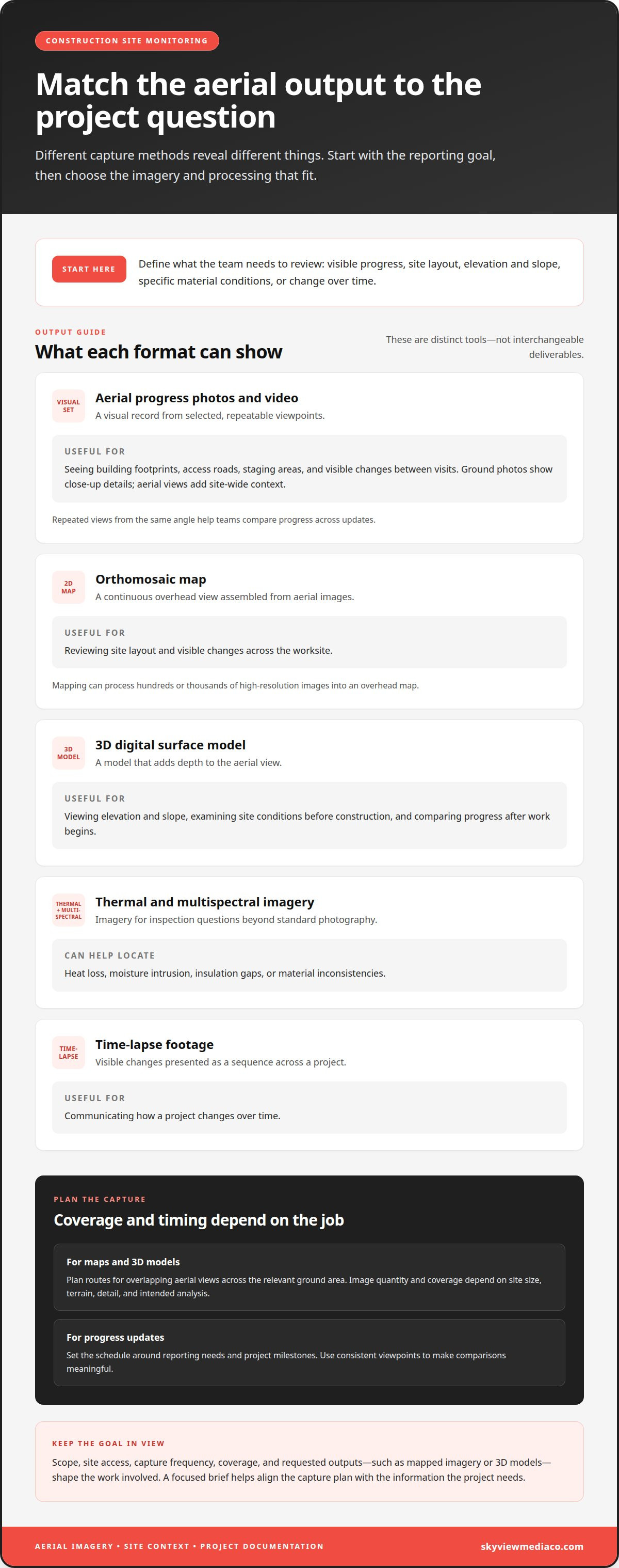
Aerial images serve different purposes depending on how teams process and review them. A visual progress set shows site conditions from selected viewpoints. Mapping takes a further step: hundreds or thousands of high-resolution images can be processed into a 2D orthomosaic map or a 3D digital surface model. According to the National Institute for Occupational Safety and Health (NIOSH), aerial photography can help inspect large worksites more efficiently than on-the-ground personnel.
Orthomosaic maps combine images into a continuous overhead view, making site layout and visible changes easier to assess. A 3D model adds depth and can show elevation and slope. Before construction begins, teams can use models to examine site conditions and identify potential issues. After work starts, repeated imagery helps compare construction progress across capture dates. The required image quantity and coverage depend on site size, terrain, detail, and the intended analysis.
Thermal and multispectral imagery serves a different inspection purpose from standard photography. These image types can help locate heat loss, moisture intrusion, insulation gaps, or material inconsistencies. Time-lapse footage, by contrast, presents visible changes across a project as a sequence. Each output answers a different question, so the reporting goal should guide the capture plan. How often should a site be photographed? Set the schedule around reporting needs and project milestones, then use consistent viewpoints to make comparisons meaningful.
Construction projects can also use aerial imagery in websites, presentations, and promotional materials. For those assets, framing should show the site clearly while keeping the intended audience and project stage in view. What affects photography pricing? Scope, site access, capture frequency, coverage, and requested outputs, such as mapped imagery or 3D models, shape the work involved. A focused brief helps align those requirements; organized construction imagery can support both project analysis and stakeholder communication.
How professionals select construction drone models and camera specifications
Professionals start with the required deliverable, then match the aircraft and camera to the construction site. Standard progress photos call for clear, consistent views; mapping and 3D modeling require imagery suitable for processing. Resolution matters because the images must retain enough detail for their intended review. Drone pilots also consider payload capacity, flight time, access, and environmental conditions.
Model specifications can clarify trade-offs. These examples illustrate different selection factors, not a universal ranking. A project requiring additional equipment may prioritize payload, while a large site may place greater weight on flight time and coverage.
For orthomosaic maps and 3D digital surface models, image quality and coverage must support image processing. Professionals plan capture routes to collect overlapping aerial views across the relevant ground area. Licensed surveyors and mappers can use drone-captured images to create 3D models. The required accuracy depends on the project’s purpose and the mapping process, so visual models shouldn’t be treated automatically as survey-grade measurements.
3D construction site models can help teams examine elevation, slope, and visible site features. When comparing a model with design plans, teams can focus review on specific locations and stages. A useful workflow defines the area, capture angle, and output first, then selects the aircraft and camera to match.
Camera choice depends on the inspection goal. A standard camera records visible conditions; thermal or multispectral imaging supports other forms of environmental analysis, such as locating heat loss or moisture intrusion. Professionals consider lighting, weather, access, and the required level of detail. These factors affect image clarity and whether the captured data suits the planned comparison or inspection.
Drone photography for construction
Construction drone photography is most useful when each capture answers a project question. Before flight, the operator defines the area, viewpoint, and purpose, whether documenting site conditions, reviewing visible work, or recording an access route. That plan helps managers interpret the visual record and compare the same locations across project stages.
For large sites, aerial surveys can cover ground that takes longer to inspect on foot. Construction drones can survey up to 120 acres per hour, compared with approximately five acres per hour using traditional methods. This reported comparison signals potential efficiency, not a substitute for choosing the right survey method. National Institute for Occupational Safety and Health (NIOSH) also notes that aerial photography can help inspect large worksites more efficiently than on-the-ground personnel.
Drone imagery can support measurements as well as visual review. For example, teams can use aerial images to measure stockpile volumes and track material quantities over time. Managers can compare captured site conditions with planned work, then direct closer inspection toward areas that appear incomplete or different. Images provide useful context, but they do not reveal hidden defects or replace a qualified technical assessment.
Accessing structures and infrastructure requires careful planning. Drones can inspect structures from a safe distance and reduce the need for personnel to climb ladders or scaffolding. The U.S. Government Publishing Office identifies infrastructure inspection as a potential drone application for construction projects. Operators must also consider active equipment, workers, nearby property, and environmental conditions before capture. Applicable regulations and airspace restrictions shape the flight plan.
The practical takeaway is to match each flight to a defined decision: document progress, review a hard-to-reach structure, or measure a stockpile. A consistent capture plan makes later comparisons more useful. Plan construction progress imagery around the areas and reporting decisions that matter to your project.
Skyview Media: Drone photography
Skyview Media provides construction drone photography for teams that need visual documentation aligned with project milestones. Its construction photography, progress videos, and timelapse footage give project teams different ways to communicate site activity. The right mix depends on the project’s reporting priorities and audience.
For construction drone photography that supports recurring updates, define the locations and milestones stakeholders need to follow. A clear scope keeps each capture relevant to project decisions. Skyview Media organizes project visuals for coordinated stakeholder reporting, giving teams a structured way to share progress.
When construction drone photography fits your project’s documentation needs, Contact Skyview Media to discuss the next step.
Set a Clear Standard for Project Documentation
Make the next step a reporting decision. Identify which stakeholders need visibility, what decisions the imagery should support, and how updates will fit existing review processes. A defined purpose keeps construction drone photography focused on operational value, rather than producing visuals without a clear use.
Skyview Media provides drone photography, construction photography, and progress videos for construction teams. Align the visuals with the project’s communication needs, whether the priority is ongoing documentation or a clear record for stakeholder updates. A consistent approach helps teams maintain a useful view of project activity.
When professional visual documentation fits your project, Contact Skyview Media to discuss the next step. Set a clear objective, establish the reporting priorities, and move forward with confidence.
Frequently Asked Questions
What is involved?
A professional construction drone photography assignment begins by defining the site areas, timing, and intended use of the images. The operator plans the capture around project activity and prepares the agreed visual materials for review. Clients can help by sharing the site address, access arrangements, milestone dates, and priority locations. For projects in New York, New Jersey, Connecticut, and Pennsylvania, these details help align the capture with local site needs.
What is construction drone photography used for?
Project teams use aerial visuals to communicate site status and support discussions among owners, contractors, and stakeholders. For instance, an update can show how access routes or staging areas have changed since an earlier phase. The images give viewers a shared reference for meetings and reports. Define the audience and decisions the visuals should support before setting the capture scope.
What equipment and software do professionals use for construction drone photography and mapping?
Professionals match the aircraft and camera to the required coverage and final output. Mapping work also uses image-processing software to assemble aerial photographs into spatial products. A standard photo set supports visual review, while mapping workflows are designed for orthomosaics or 3D models. The requested deliverable guides equipment and processing choices, so teams can avoid outputs that don’t support their project decisions.
How do professionals plan and conduct a construction site drone photography flight, and what should clients provide?
Flight planning starts with the site boundary, capture priorities, and timing. Clients can share access instructions, active work zones, site contacts, and locations that need closer visual attention. Upcoming milestones help align the flight with meaningful project changes. The operator uses these details to organize the capture plan and coordinate with site activity, producing imagery suited to the project’s reporting needs.
What deliverables can construction drone photography provide, such as progress reports, orthomosaics, and 3D models?
Construction drone photography can provide aerial photos, progress videos, and organized visual updates. Mapping workflows can produce orthomosaics or 3D models when those outputs suit the project’s purpose. Teams can also use selected images in progress reports or stakeholder presentations. Specify the intended audience and use for each deliverable so the final package supports review, communication, or project records.